
Map of Kentucky with Bullitt County highlighted
The first time I ever heard of Bullitt County was when I started researching my paternal grandmother, Georgia Mary Coakley Stevens. This is the county in which she lived during her childhood and where my father was born. Her family had been in Kentucky for several generations by that time. More on that in another post.
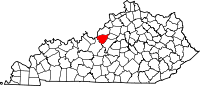
Bullitt County was founded in 1796 and is located in the far western Bluegrass region known as the Knobs.
European colonization of the Americas led to competing claims to the lands west of the Appalachians and east of the Mississippi river with France ultimately ceding control to Britain at the end of the French and Indian War in 1763. Veterans of the war were promised land and in 1773 Captain Thomas Bullitt was sent on a surveying expedition of the area around the Falls of the Ohio by the governor of Virginia. During his explorations of the land that would become Bullitt County, he came upon an unusually large salt lick subsequently named after him: Bullitt’s Lick. [6]
Bullitt’s Lick became an important saltwork to the region – supplying salt by pack train and flatboat as far off as Illinois. In fact, the Bullitt’s Lick saltwork was Kentucky’s first industry and in production until around 1830, when the steamboat and importation brought access to less expensive sources of salt.
The first settlement of the area and the first station on the Wilderness Road between Harrodsburg and the Falls of the Ohio was a fort called Brashear’s Station or the Salt River Garrison, built in 1779 at the mouth of Floyd’s Fork. Shepherdsville, named after Adam Shepherd – a prosperous business man who purchased the land near the Falls of Salt River in 1793, is the oldest town and became the county seat.
In December of 1796[1] the county of Bullitt – named after Thomas Bullitt’s nephew and Kentucky’s first Lieutenant Governor Alexander Scott Bullitt – was created from land given by Jefferson and Nelson counties through an act approved on December 13, 1796 by the Kentucky General Assembly. In 1811, the northwestern area of the county expanded to include land given by Jefferson County. In 1824, an eastern area of the county was given to help form Spencer County.[7]
